ADS Arch Search’s “Mapping Medieval Townscapes: A Digital Atlas Of The New Towns Of Edward I” uses mapping technology to create a map of how Wales and England looked under the reign of King Edward I:
Using mapping as a medium, the project examined how urban landscapes were shaped in the middle ages, the project furthers an understanding of the forms and formation of medieval towns. It is the first project to have used spatial technologies – Geographical Information Systems (GIS) and Global Positioning Systems (GPS) – as a basis for mapping and analysing medieval urban landscapes. The project team was Dr Keith Lilley (director), Dr Chris Lloyd (co-director), and Dr Steven Trick (researcher) and the research was conducted at Queen’s University Belfast.
The project focused on a group of ‘new towns’ situated in Wales and England and established in the reign of King Edward I. The towns were all founded between 1277 and 1303. The project looked at thirteen of them in detail: Aberystwyth, Beaumaris, Caernarfon, Caerwys, Conwy, Cricieth, Flint, Harlech, Holt, Newborough, Overton, Rhuddlan, and Winchelsea.
The project’s aims were to: firstly, characterise the urban forms of Edward’s new towns; secondly, establish their original layout and design; thirdly identify common aspects of their design; fourthly, examine the agents and the decision-making processes involved in their formation. The project also had as one of its main aims the creation of an interactive, digital historic towns atlas made available to a broad audience to disseminate awareness and knowledge of medieval towns in general, and stimulate interest in Edward I’s new towns in particular.
To view the pages, Javascript must be enabled, but it’s worth it to get a glimpse of what the communities around Wales and England may have looked like during your ancestor’s time.
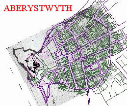 I took a look at the new town of Aberystwyth’s Interactive Map and found that I could easily change different aspects shown on the map, but I had trouble zooming in for a closer look. While the interactive maps are supposed to work with Firefox, I had to to switch to IE to make them work.
Still, it’s a very interesting tool and may help you in your family history research to get a feel for a place in history. I expect more historical mapping services to begin to appear on the web soon.
Most Recent Articles by Lorelle VanFossen
- The Myths and Mysteries and Hunt for Nicholas Knapp
- The Perpetual Calendar
- GenSmarts: Reminder to Not Assume
- Gensmarts Saves Your Family History Research Life
- Digging Through Historical Newspapers Online