In The Peshtigo River, Marinette County’s Greatest Remaining Natural Resource was put together by Jim Frink on the High Falls Flowage site, a site about the lake and surrounding land and rivers, based upon a report in “The Water Powers of Wisconsin” by Leonard S. Smith, C. E. which was published by the State of Wisconsin, Madison, in 1908. The report was commissioned the state and the Wisconsin Geological and Natural History Survey. Frink excerpted the information about the Peshtigo River for his site, and I’ve highlighted a few bits that describe the river in context to the impact and influence it had on my Knapp family living in Taylor Rapids along the Peshtigo River.
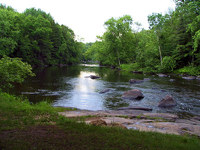
As far as rivers go, the Peshtigo is neither very big or significant. In many places an average person can throw a stone across it. Its drainage area is listed as 1,123 square miles, which includes roughly half of Marinette county. Its total length is listed at 94 miles, or 80 miles the way the crow flies. It does have some unique features, however. One is that its drainage area only has an average width of 14 miles with no tributary streams of any great significance feeding it. Although its water has a rather dark color derived from its swampy sources, it seems to be relatively free of pollutants or contamination. This is probably because for most of its course the shoreline is forested and wild, while the only cities of any consequence are Peshtigo and possibly Crivitz which are located far downstream from the source. Another feature, which is very important is that in its 94 mile total length, there is a drop in elevation of 1,040 feet, or an average of over 11 feet per mile. This is the largest drop per mile of any major river system in Wisconsin, and provides for more and larger rapids than any other river in the state. This compares with an average of 5.1 feet per mile for the Wolf River, 6.7 feet for the Menominee, and 10.8 feet for the Oconto. All of these rivers contain stretches of rapids, but not to the extent of the Peshtigo. The upper two-thirds of the river flows through pre-Cambrian igneous rocks while the lower third basically has a sandstone and limestone base.
This rapid flow, the fact that the river is relatively shallow and meanders considerably in the first few miles must have ruled out the Peshtigo as a viable means of transportation for the early settlers. They undoubtedly considered it as a hindrance and just another natural barrier in the way as civilization moved inland. It is even questionable if the lumbermen truly found it to their liking for moving logs from the forests to the mills due to the many rapids which must have caused considerable jams and danger. Their history and adventures would make for an entirely different story, however.
Having survived the arrival of settlers, the logging industry, the building of dams and bridges and the Peshtigo Fire, the river flowed peacefully into the 20th century, still flowing relatively unchanged and performing the tasks which nature intended.
The report admitted that while it might be possible to consider dam sites along the river, it was recommended to not. In 1905, the Wisconsin government was working hard to electrify their entire state and dams were the number one source for electricity beyond coal plants. This caused them to initiate a survey of the river to test its worthiness for damming it. For the most part, it has remained pretty much as it was, especially in the area where my ancestors grew up.
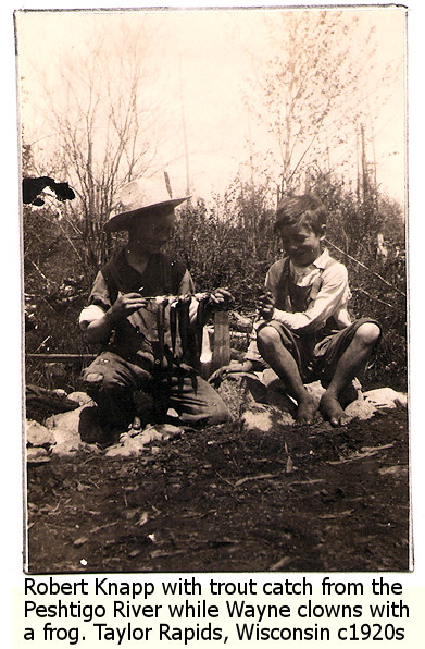
Brothers Robert F. Knapp and Wayne Knapp have written extensively in published and unpublished stories about the “Old Peshtigo River” in stories such as Lunch On the River on Old Jim With Nonie and Wayne, Trapped On The Island, and poems like Early Memories of Taylor Rapids, Wisconsin, and The 1967 Trip Back to Taylor Rapids, Wisconsin, where my two great uncles revisited their former homestead. And there are more stories of Taylor Rapids and the Peshtigo River on the way as I edit them.
I don’t have many pictures of the river in my files, from the family or from my trip there, but I want to go back and photograph more of the river that served them during their many years there. So I needed some words to help me understand more about the importance of this river for my research. Robert and Wayne talk about how there was a loading ramp/doc for the logging camps that had been abandoned about the time they were entering their early teens, and how logs from there were then loaded up onto the train that took the logs from the camps into the bigger cities, mills, and beyond.
My ancestors lived very close to the land, so it’s important that I understand that land. For many researchers, the buildings, city, and its culture is their focal point for some of their family’s history, but for this group of logging folks, it’s the forest, lakes, rivers, and sand plains of northern Wisconsin. Through their stories and my understanding of the land, I get a better picture of how they lived.
Most Recent Articles by Lorelle VanFossen
- The Myths and Mysteries and Hunt for Nicholas Knapp
- The Perpetual Calendar
- GenSmarts: Reminder to Not Assume
- Gensmarts Saves Your Family History Research Life
- Digging Through Historical Newspapers Online


Pingback: Lorelle’s World as of May 28th, 2011